Computes the neighborhoods of the cells of a raster. Neighborhoods are not computed for cells with missing values.
ngbList(r, rNumb = FALSE, attTbl = NULL)Arguments
- r
single or multi-layer raster of the class
SpatRaster(seehelp("rast", terra)).- rNumb
logic, the neighbors of a raster cell are identified by cell numbers (
rNumb=FALSE) or by row numbers (rNumb=TRUE). If true, the argumentattTblcannot be NULL.- attTbl
data.frame, the attribute table returned by the function
attTbl(seeattTbl). It is required only if the argumentrNumb=TRUE.
Value
Named list of integer vectors.
Details
Definition of neighborhood
A cell with coordinates
(x, y)has 8 neighbors with coordinates:(x±1, y),(x, y±1)and(x±1, y±1). Cells on the edge of a raster have less than 8 neighbors.
Neighborhoods (rNumb=FALSE)
Neighbors are identified by their cell numbers if the argument
rNumb=FALSE.
Neighborhoods (rNumb=TRUE)
Neighbors are identified by their positions in the attribute table (i.e. row numbers) if the argument
rNumb=TRUE;When the argument
rNumb = TRUE, neighbors with missing values are omitted;(scapes)Classificationsare faster when the list of neighborhoods uses row numbers.
Neighborhood names
The list of neighborhoods is named.
When
rNumb = FALSE, the element name identifies the raster cell to which the neighborhood refers. For instance, the element with name"n"stores the neighborhood of the raster celln.When
rNumb = TRUE, the element name identifies the row number to which the neighborhood refers. For instance, the element with name"n"stores the neighborhood of the raster cell located in thenthrow of the attribute table (attTbl$Cell[n]).
Note
There is always a correspondence between the indices of the attribute table (
attTbl) and the indices of the list of neighborhoods: the 1st element of the list corresponds to the neighbors of the cell stored in the 1st row of the attribute table; the 2nd element corresponds to the 2nd row; etc.There is a correspondence between the raster cell number and the indices of the list of neighborhoods only when no missing value is present in the raster.
Examples
library(scapesClassification)
library(terra)
## CREATE A DUMMY RASTER AND COMPUTE ATTRIBUTE TABLE ##
r <- terra::rast(matrix(c(NA,100,100,NA,100,100,0,0,0),
nrow = 3,
ncol = 3,
byrow = TRUE))
at <- attTbl(r, var_names = c("dummy_var"))
## RASTER CELL NUMBERS ##
rcn <- r; rcn[] <- 1:9
## PLOT DATA AND CELL NUMBERS ##
oldpar <- par(mfrow = c(1,2))
m <- c(4, 1, 4, 1)
plot(r, col="grey90", colNA="red3", mar=m, asp=NA, axes=FALSE, legend=FALSE)
text(r)
lines(r)
mtext(side=3, line=0.2, adj=0, cex=1.5, font=2, "Dummy_var")
legend("bottomright", ncol = 1, bg = "white", fill = c("red3"),
legend = c("NA cells (1 and 4)"))
plot(rcn, col="grey90", mar=m, asp = NA, axes=FALSE, legend=FALSE)
text(rcn)
lines(rcn)
mtext(side=3, line=0.2, adj=0, cex=1.5, font=2, "Cell numbers")
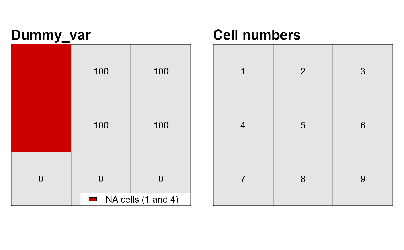 par(oldpar)
## NEIGHBORHOODS - CELL NUMBERS ##
# Cells 1 and 4 are omitted because they are NAs
nbs_CELL <- ngbList(r, rNumb = FALSE)
nbs_CELL
#> $`2`
#> [1] 1 3 4 5 6
#>
#> $`3`
#> [1] 2 5 6
#>
#> $`5`
#> [1] 1 2 3 4 6 7 8 9
#>
#> $`6`
#> [1] 2 3 5 8 9
#>
#> $`7`
#> [1] 4 5 8
#>
#> $`8`
#> [1] 4 5 6 7 9
#>
#> $`9`
#> [1] 5 6 8
#>
## NEIGHBORHOODS - ROW NUMBERS ##
# Cells 1 and 4 are omitted because they are NAs
nbs_ROW <- ngbList(r, rNumb = TRUE, attTbl = at)
nbs_ROW
#> $`1`
#> [1] 2 3 4
#>
#> $`2`
#> [1] 1 3 4
#>
#> $`3`
#> [1] 1 2 4 5 6 7
#>
#> $`4`
#> [1] 1 2 3 6 7
#>
#> $`5`
#> [1] 3 6
#>
#> $`6`
#> [1] 3 4 5 7
#>
#> $`7`
#> [1] 3 4 6
#>
# Numbers in 'nbs_ROW' refer to row numbers
# (e.g. number 1 refers to the cell #2)
at$Cell[1]
#> [1] 2
# (e.g. number 2 refers to the cell #3)
at$Cell[2]
#> [1] 3
# (e.g. number 5 refers to the cell #7)
at$Cell[5]
#> [1] 7
## CONSIDER THE NEIGHBORHOOD OF CELL #2 ##
# Cell #2 corresponds to the 1st element of both 'nbs_CELL' and 'nbs_ROW'
# because raster cell 1 is an NA-cell
r[1]
#> lyr.1
#> 1 NA
# Neighborhood cell #2 corresponds to cells:
nbs_CELL[1]
#> $`2`
#> [1] 1 3 4 5 6
#>
# Neighborhood cell #2 corresponds to rows:
nbs_ROW[1]
#> $`1`
#> [1] 2 3 4
#>
# Rows can be converted to cell numbers
at$Cell[ nbs_ROW[[1]] ]
#> [1] 3 5 6
# Note that 'at$Cell[ nbs_ROW[[1]] ]' is not equal to 'nbs_CELL'
identical( at$Cell[ nbs_ROW[[1]] ] , nbs_CELL[[1]] )
#> [1] FALSE
# This is because raster cells 1 and 4 (NA-cells) are omitted in 'nbs_ROW'
setdiff(nbs_CELL[[1]], at$Cell[ nbs_ROW[[1]] ])
#> [1] 1 4
r[c(1,4)]
#> lyr.1
#> 1 NA
#> 2 NA
par(oldpar)
## NEIGHBORHOODS - CELL NUMBERS ##
# Cells 1 and 4 are omitted because they are NAs
nbs_CELL <- ngbList(r, rNumb = FALSE)
nbs_CELL
#> $`2`
#> [1] 1 3 4 5 6
#>
#> $`3`
#> [1] 2 5 6
#>
#> $`5`
#> [1] 1 2 3 4 6 7 8 9
#>
#> $`6`
#> [1] 2 3 5 8 9
#>
#> $`7`
#> [1] 4 5 8
#>
#> $`8`
#> [1] 4 5 6 7 9
#>
#> $`9`
#> [1] 5 6 8
#>
## NEIGHBORHOODS - ROW NUMBERS ##
# Cells 1 and 4 are omitted because they are NAs
nbs_ROW <- ngbList(r, rNumb = TRUE, attTbl = at)
nbs_ROW
#> $`1`
#> [1] 2 3 4
#>
#> $`2`
#> [1] 1 3 4
#>
#> $`3`
#> [1] 1 2 4 5 6 7
#>
#> $`4`
#> [1] 1 2 3 6 7
#>
#> $`5`
#> [1] 3 6
#>
#> $`6`
#> [1] 3 4 5 7
#>
#> $`7`
#> [1] 3 4 6
#>
# Numbers in 'nbs_ROW' refer to row numbers
# (e.g. number 1 refers to the cell #2)
at$Cell[1]
#> [1] 2
# (e.g. number 2 refers to the cell #3)
at$Cell[2]
#> [1] 3
# (e.g. number 5 refers to the cell #7)
at$Cell[5]
#> [1] 7
## CONSIDER THE NEIGHBORHOOD OF CELL #2 ##
# Cell #2 corresponds to the 1st element of both 'nbs_CELL' and 'nbs_ROW'
# because raster cell 1 is an NA-cell
r[1]
#> lyr.1
#> 1 NA
# Neighborhood cell #2 corresponds to cells:
nbs_CELL[1]
#> $`2`
#> [1] 1 3 4 5 6
#>
# Neighborhood cell #2 corresponds to rows:
nbs_ROW[1]
#> $`1`
#> [1] 2 3 4
#>
# Rows can be converted to cell numbers
at$Cell[ nbs_ROW[[1]] ]
#> [1] 3 5 6
# Note that 'at$Cell[ nbs_ROW[[1]] ]' is not equal to 'nbs_CELL'
identical( at$Cell[ nbs_ROW[[1]] ] , nbs_CELL[[1]] )
#> [1] FALSE
# This is because raster cells 1 and 4 (NA-cells) are omitted in 'nbs_ROW'
setdiff(nbs_CELL[[1]], at$Cell[ nbs_ROW[[1]] ])
#> [1] 1 4
r[c(1,4)]
#> lyr.1
#> 1 NA
#> 2 NA